24-09-2026
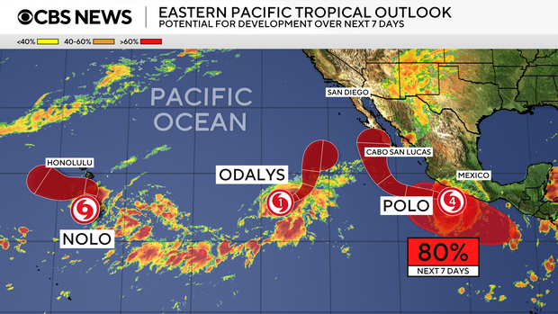
Hurricane Polo is bringing heavy rain and powerful waves to Mexico’s Pacific coast, while Tropical Storm Nolo is moving toward Hawaii and could cause catastrophic flooding. Early Thursday, Polo was about 130 miles (209 kilometres) south-southwest of Zihuatanejo, moving northwest at 7 mph (11 kph). Forecasters expected it to turn west-northwest and move farther out to sea before turning northwest on Saturday. Polo was forecast to remain a Category 5 hurricane as it travels along Mexico’s coast. Although its eye and strongest winds were expected to stay offshore, the US National Hurricane Center warned that heavy rain could trigger life-threatening flooding and landslides.
In Hawaii, a hurricane watch was issued for Hawaii County as officials prepared for Nolo, which could reach the island on Friday or Saturday. National Weather Service meteorologist John Bravender said the storm might strengthen into a major hurricane. Hawaii County Mayor Kimo Alameda urged residents to prepare emergency kits containing food, water and medications, trim vegetation and clear drains. He emphasized that the situation was serious and that rain was already arriving.
State and local offices announced closures ahead of the expected conditions. Public schools and state and county offices on Hawaii’s Big Island were set to close Thursday and Friday, while Maui County planned to close schools and offices on Friday. The article focuses on the potential hazards from both systems—particularly flooding and landslides—and the precautions being taken in Hawaii.
Entities: Hurricane Polo, Tropical Storm Nolo, Mexico’s Pacific coast, Zihuatanejo, Michoacán • Tone: urgent • Sentiment: negative • Intent: warn
24-09-2026
Hurricane Polo regained Category 5 strength early Thursday while remaining offshore of Mexico’s Pacific coast. The National Hurricane Center expected the storm to stay over the ocean and move farther out to sea, though its outer rainbands were already spreading across southwestern Mexico. Polo’s intensity had fluctuated: its maximum sustained winds reached 180 mph at one point, and after being a Category 4 on Wednesday, its winds rose to 160 mph Thursday. Forecasters said some further strengthening was possible and that Polo would remain a powerful major hurricane for several days.
As of early Thursday, Polo’s center was about 175 miles from Zihuatanejo, Guerrero, moving northwest at 9 mph. Hurricane-force winds extended up to 40 miles from the center, with tropical-storm-force winds reaching about 125 miles. Tropical-storm conditions were forecast along parts of the coast. Authorities warned that heavy rain could cause life-threatening flooding and mudslides, particularly in steep terrain. Guerrero could receive 4 to 6 inches of rain, with up to 8 inches in some areas; coastal sections of Oaxaca, Colima and Jalisco could receive 2 to 4 inches. Dangerous surf and rip currents also posed a threat and could contribute to flooding. Mexico issued a tropical-storm warning for parts of Guerrero and Colima, and a watch for portions of Jalisco.
Polo rapidly intensified from 45 mph winds Monday morning to 150 mph around the same time Tuesday, meeting the definition of extreme rapid intensification. The hurricane center called the change “truly remarkable.” Polo’s central pressure ranked it as the Eastern Pacific’s second-strongest hurricane on record, behind Hurricane Patricia in 2015; its wind speed tied Hurricane Rick’s 2009 record as the region’s third-highest. The article attributes elevated Pacific cyclone activity to unusually strong El Niño conditions, which brought warmer waters, moist air and reduced wind shear. Separately, Tropical Storm Nolo formed in the Pacific on Wednesday, prompting a hurricane watch for Hawaii’s Big Island, and was forecast to become a hurricane Thursday.
Entities: Hurricane Polo, Tropical Storm Nolo, U.S. National Hurricane Center, Mexico, Zihuatanejo • Tone: neutral • Sentiment: negative • Intent: inform
24-09-2026
A Euronews video report shows residents in Acapulco, on Mexico’s Pacific coast, working together to pull a boat out of the water as large waves batter the shoreline. The group struggles to haul the vessel ashore while heavy swells continue breaking along the beach, apparently trying to protect it from the rough conditions.
The effort takes place as Hurricane Polo passes offshore. The report says the storm was not expected to make landfall in Mexico. It had weakened from Category 5—the highest hurricane category—to Category 4 while moving along the Pacific coast. The article describes residents taking precautions amid the storm’s powerful waves, but gives no further details about damage, injuries, official warnings, or the boat’s eventual condition.
The video’s focus is the residents’ collective attempt to get the boat to safety, rather than a broader account of the hurricane or its impacts. Its accompanying text emphasizes the contrast between the people’s effort and the force of the surf. The report provides a brief, factual account of a local response to hazardous coastal conditions, with the video serving as its main visual evidence.
Entities: Acapulco, Mexico, Mexico’s Pacific coast, Hurricane Polo, Category 5 hurricane • Tone: neutral • Sentiment: neutral • Intent: inform