23-09-2026
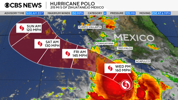
Hurricane Polo, moving slowly off Mexico’s Pacific coast, has weakened from a Category 5 to a Category 4 storm but remains extremely powerful. The US National Hurricane Center said it was expected to move toward south-western Mexico, bringing intense wind and rain, although it was not forecast to make landfall. A US National Oceanic and Atmospheric Administration Hurricane Hunter aircraft recorded sustained winds near 180 mph, with stronger gusts. The storm could still strengthen in the unusually warm ocean conditions that are supplying it with energy.
Forecasters warned that Polo could bring torrential rain to parts of Mexico’s south-west coast, with totals of up to 6 inches and as much as 8 inches in some locations. The rainfall could cause life-threatening flooding and mudslides, particularly in steep areas. Large ocean swells and dangerous surf are also expected. President Claudia Sheinbaum urged Pacific-coast residents to remain vigilant and identified Jalisco, Colima and Michoacan as states at risk, while saying available information suggested the storm would not directly hit the coast.
The article links Polo’s strength to exceptionally warm Pacific waters associated with El Niño. On 19 September, daily sea surface temperatures in a key central-eastern Pacific region were 3.05°C above average, exceeding the previous record set during the strong 2015 El Niño. While some longer-term measurements have not yet reached records, scientists expect the phenomenon to peak later in the year. El Niño occurs naturally every two to seven years, typically lasting about a year, as Pacific trade winds weaken or reverse and warm water shifts eastward. The ocean releases heat into the atmosphere, potentially boosting global temperatures and altering weather patterns worldwide.
Entities: Hurricane Polo, Mexico, south-western Mexico, Jalisco, Colima • Tone: urgent • Sentiment: negative • Intent: warn
23-09-2026
Hurricane Polo, a powerful Category 4 storm, was spinning off Mexico’s southwestern Pacific coast early Wednesday and was expected to skirt the shoreline rather than make landfall. The National Hurricane Center reported that Polo’s maximum sustained winds had eased to 150 mph after reaching as high as 180 mph on Tuesday. Although the storm could fluctuate in strength, forecasters expected it to remain a major hurricane. At the time of the report, Polo was about 165 miles offshore from Zihuatanejo, Guerrero, moving north at only 2 mph. Its outer rain bands were reaching the coast, and tropical-storm conditions were forecast to begin affecting parts of the shoreline on Wednesday. Officials warned that heavy rain could cause life-threatening flooding and mudslides, particularly in steep terrain. The Mexican government issued a tropical-storm warning for coastal areas from Tecpan de Galeana in Guerrero to Punta San Telmo in Michoacán, and a watch from Punta San Telmo north to Playa Perula in Jalisco. Rainfall totals could reach 3 to 6 inches in parts of Guerrero and Michoacán, with up to 8 inches in isolated areas; coastal sections of Oaxaca, Colima and Jalisco could receive 2 to 4 inches. Dangerous surf and rip currents were also expected, with the potential to contribute to flooding. Polo was far south of Baja California, though longer-range forecasts suggested it might turn toward the peninsula the following week. The article describes Polo as the Eastern Pacific’s second-strongest hurricane on record by central pressure, behind Patricia in 2015, and tied for third by wind speed. It attributes unusually active Pacific cyclone conditions this year in part to a strong El Niño, warmer waters, moist air and reduced wind shear.
Entities: Hurricane Polo, National Hurricane Center, Zihuatanejo, Guerrero, Michoacán • Tone: urgent • Sentiment: neutral • Intent: inform
23-09-2026
Hurricane Polo’s outer rainbands reached Mexico’s Pacific coast on Wednesday, bringing a risk of life-threatening flooding and mudslides even though the storm’s forecast track was expected to keep its center offshore. The US National Hurricane Center (NHC) said Polo’s core would remain near the coast of southwestern Mexico for the next day or two, producing heavy rain. Guerrero and Michoacan were forecast to receive 3 to 8 inches (8 to 20 centimetres) of rain through Thursday. Rainfall could also affect coastal areas of Oaxaca, Colima and Jalisco.
Polo had weakened from Category 5 to Category 4, with maximum sustained winds near 155 mph (250 km/h) and stronger gusts. The NHC warned that the hurricane could fluctuate in intensity but was expected to remain a very powerful major hurricane for several days.
Mexico’s government said it was coordinating preparedness and prevention efforts along the Pacific coast. According to the Security Ministry, command posts were active in Michoacan, Colima, Jalisco and Guerrero. Their work included risk inspections, assessing conditions, preparing temporary shelters and carrying out preventive evacuations if circumstances required them. The report describes preparations underway as authorities respond to the expected rainfall and associated hazards.
Entities: Hurricane Polo, US National Hurricane Center (NHC), Mexico, Acapulco, Guerrero • Tone: urgent • Sentiment: negative • Intent: warn
23-09-2026
The article reports that California has declared a state of emergency as forecasts point to an exceptionally strong El Niño this autumn and winter, while Category 5 Hurricane Polo remains offshore of southwestern Mexico. Federal forecasts put the chance of a very strong El Niño above 90%, with a 75% probability it could reach historic strength. California Gov. Gavin Newsom’s emergency order is intended to help agencies prepare early, coordinate with local and tribal governments, and position equipment and personnel for severe weather. The California National Guard is being readied for flood response, search and rescue, engineering, and logistics.
California could face heavy rain, flooding, mudslides, landslides, mountain snow, coastal erosion, and closures on transportation links. The article says El Niño can raise coastal water levels and strengthen Pacific storm waves, compounding sea-level rise associated with climate change. These hazards coincide with an 18-year astronomical high-tide cycle. University of California, Santa Cruz researcher Patrick Barnard said King Tides will be higher than usual and that Pacific storm wave energy has been about 30% greater during El Niño years, reaching 50% in 2015–16. A projected coastal water-level increase of 15–30 centimetres could expose an additional 170,000 people and $60 billion in property to risk compared with a non-super El Niño year.
Meanwhile, Polo intensified exceptionally quickly, with winds rising by roughly 175 kilometres per hour from Monday to Tuesday morning. Its winds peaked near 285 km/h before easing to about 270 km/h, and the storm remained an extremely dangerous Category 5. The National Hurricane Center described its strengthening as remarkable; its rapid intensification was among the fastest recorded in the eastern Pacific. A Tropical Storm Warning covered part of Mexico’s southwest coast. Though Polo’s core was expected to remain offshore, heavy rainfall threatened life-threatening flooding and mudslides in Guerrero and Michoacán. Mexican authorities suspended classes in affected coastal areas, monitored rivers, and urged residents to avoid floodwaters and prepare routes to higher ground.
Entities: California, Gavin Newsom, Hurricane Polo, Super El Niño, National Hurricane Center • Tone: urgent • Sentiment: negative • Intent: inform