05-09-2026
The United Nations General Assembly has endorsed a resolution encouraging governments and institutions to adopt the Equal Earth map projection, which depicts Africa and other continents in proportions closer to their actual landmass. The resolution, sponsored by Togo and supported by members of the African Union, passed with 164 votes in favour. The United States voted against it, while Serbia, Estonia, Georgia, Lithuania, Moldova and Ukraine abstained.
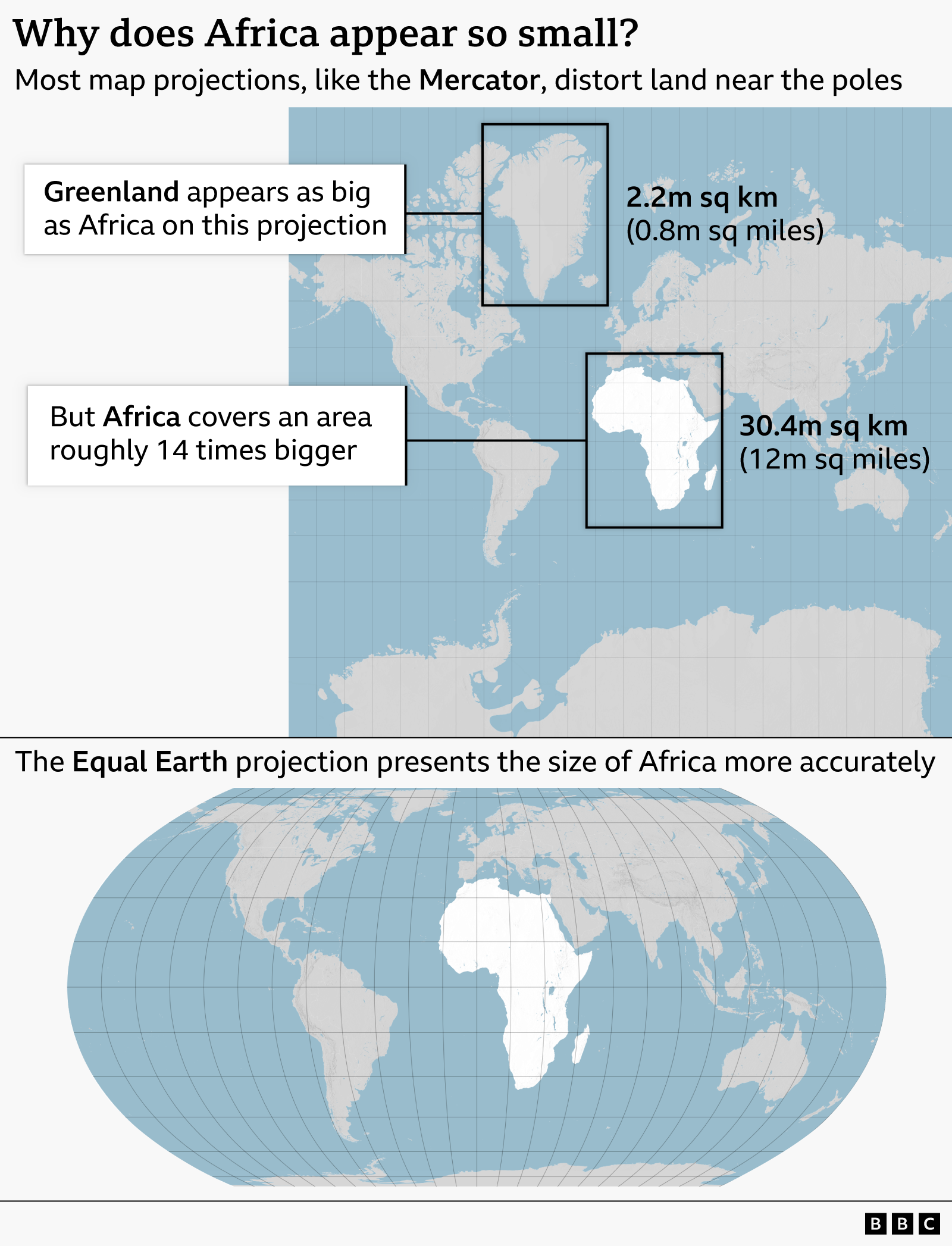
The initiative follows a campaign led by African countries and advocacy organizations, including Africa No Filter, which argued that widely used maps can shape inaccurate perceptions of the world. The campaign particularly criticized the Mercator projection, a 16th-century map created by Flemish cartographer Gerardus Mercator for maritime navigation. Because the Mercator projection enlarges areas near the poles and reduces the apparent size of regions closer to the equator, Greenland can appear comparable in size to Africa, despite Africa being approximately 14 times larger.
The UN stressed that the resolution does not prohibit the Mercator projection or mandate a specific replacement. Instead, it encourages the use of Equal Earth, a projection developed in 2018 that accounts more effectively for the Earth’s curvature and represents continents in closer proportion to their true sizes.
Supporters described the change as a way to improve education, media, business and digital representations of geography. Togo’s Foreign Minister Robert Dussey said maps influence how people understand the world, while French Foreign Minister Jean-Noël Barrot called correcting distorted representations “an act of truth.” Geographers acknowledged that the Mercator projection remains useful for navigation but argued that it has little justification for most other uses. The resolution therefore represents a symbolic and educational challenge to a longstanding convention rather than a compulsory global replacement of one map with another.
Entities: United Nations General Assembly, Africa, Togo, African Union, United States • Tone: analytical • Sentiment: positive • Intent: inform
05-09-2026
The article examines a United Nations General Assembly resolution supporting wider use of the Equal Earth map projection, which presents continents in more accurate proportion to their actual land areas. The resolution, led by African countries and driven by Togo, received support from 164 countries. The United States voted against it, while Serbia, Estonia, Georgia, Lithuania, Moldova and Ukraine abstained.
The debate centers on the distortion created by the Mercator projection, developed by Flemish cartographer Gerardus Mercator in 1569 for maritime navigation. Although Mercator preserves the shapes and angles of landmasses, it significantly enlarges regions near the poles and compresses areas around the Equator. As a result, Europe and North America appear disproportionately large, while Africa and South America appear smaller than they are. Greenland, for example, looks nearly as large as Africa on a Mercator map despite being about 14 times smaller.
The article details Africa’s actual size—approximately 30.3 million square kilometres—and compares it with Latin America, Oceania, South Asia and Europe. Africa alone could contain the United States, China, India and most of Europe. France, a co-sponsor of the resolution, said it would stop using the Mercator projection, arguing that correcting distorted visual representations is an act of truth. The US representative criticized the UN for focusing on historical map projects instead of more urgent global problems.
Equal Earth was created in 2018 by cartographers Bojan Savric, Tom Patterson and Bernhard Jenny. Unlike Mercator, it preserves relative continental areas while retaining reasonably recognizable shapes. However, the resolution is nonbinding: it does not prohibit Mercator or require governments to replace it. Instead, it encourages institutions and governments to adopt Equal Earth as a more accurate default world map.
Entities: United Nations General Assembly, Equal Earth cartographic projection, Mercator projection, Africa, Togo • Tone: analytical • Sentiment: neutral • Intent: inform
05-09-2026
The supplied material does not include the body of the AP News article. It consists almost entirely of AP’s navigation menus, topic listings, newsletters, and unrelated headlines, along with the article title and URL. Based on the headline and URL, the article reports that the United Nations General Assembly voted to endorse or adopt a world map designed to represent Africa’s size more accurately than the widely used Mercator projection.
The issue concerns the way map projections distort the apparent size of countries and continents. The Mercator projection preserves certain directional properties useful for navigation but greatly enlarges areas nearer the poles and makes Africa appear much smaller relative to places such as Greenland and Europe. An equal-area projection, identified in the URL and headline context as the Equal Earth projection, is intended to portray the relative size of landmasses more faithfully.
The reported UN action appears to be primarily symbolic and educational: it highlights geographic distortion, challenges Eurocentric visual conventions, and encourages the use of maps that give viewers a more accurate understanding of the world’s land areas. The decision is also significant because Africa is the second-largest continent by area, yet its size is often underestimated when shown on conventional Mercator-based maps.
Because the article’s body is missing, the supplied content does not establish the vote count, the resolution’s sponsor, which UN materials would use the new projection, whether adoption is mandatory, or what diplomats and cartographers said during the debate. Those details should not be inferred from the headline alone.
Entities: United Nations General Assembly, United Nations, Africa, Equal Earth projection, Mercator projection • Tone: analytical • Sentiment: neutral • Intent: inform
05-09-2026
The UN General Assembly has voted in favour of a non-binding resolution calling for greater use of world maps that accurately represent the size of Africa. Sponsored by Togo and supported by African Union members, the “Correct the Map” resolution received 164 votes, including support from France and the UK. The United States was the only country to vote against it, while six countries abstained.
The resolution challenges the continued dominance of the Mercator projection, a 16th-Century map designed by Flemish cartographer Gerardus Mercator for navigation. Although useful for showing direction and shape, the projection significantly distorts the relative size of landmasses. It makes regions near the equator, including Africa, appear smaller, while enlarging areas closer to the poles. Africa is roughly 14 times larger than Greenland, despite appearing similar in size on many Mercator maps.
Supporters argue that this distortion is not merely technical. They say it has influenced how Africa is perceived politically, economically and culturally, potentially minimizing the continent’s resources, population, development needs and investment opportunities. Togo’s foreign minister, Robert Dussey, described a fair map as a foundation for a fair world, while campaigners said the issue concerns Africa’s wider misrepresentation and “cognitive justice.”
The African Union’s 54 member states adopted the Equal Earth projection in February. Developed by cartographers in 2018, it is intended to represent the relative sizes of continents more accurately. France has also indicated that it will stop using the Mercator map.
The United States opposed the resolution, arguing that the General Assembly should focus on international peace, prosperity and diplomatic relations rather than historical map projects. Despite that criticism, supporters maintain that changing a map cannot alter the world itself, but can correct a representation that has shaped public understanding of it.
Entities: United Nations General Assembly, Africa, Mercator projection, Correct the Map resolution, Togo • Tone: analytical • Sentiment: neutral • Intent: inform
05-09-2026
The article examines how different world-map projections represent the Earth and the trade-offs involved in converting a spherical planet into a flat map. It begins with the United Nations’ adoption of the Equal Earth projection through its “Correct the Map” resolution, intended to address the way the widely used Mercator projection dramatically exaggerates the size of landmasses near the poles. On Mercator maps, Greenland appears roughly comparable in size to Africa, despite Africa being about 14 times larger in reality.
Created by Flemish cartographer Gerardus Mercator in 1569, the Mercator projection was designed primarily for ocean navigation. Its straight lines accurately represent constant compass bearings, making it highly useful for sailors. However, preserving direction and angles causes increasing distortion of area toward the poles. Critics argue that this distortion can influence perceptions of the political and economic importance of different regions, particularly Africa.
The Equal Earth projection, developed in 2018 and adopted by African Union members in 2026, presents land areas more accurately while maintaining relatively recognizable shapes. However, it cannot preserve accurate distance, direction and shape simultaneously. The article also discusses the Peters projection, which represents land area more fairly but significantly distorts the shapes of continents and is unsuitable for navigation.
Other approaches include the azimuthal equidistant projection, which shows correct distances and directions from a selected central point, and south-up maps, which rotate the conventional north-up orientation. Overall, the article emphasizes that no flat map can perfectly represent every characteristic of a globe; each projection prioritizes different purposes and introduces its own distortions.
Entities: Mercator projection, Equal Earth projection, Peters projection, Gerardus Mercator, James Cheshire • Tone: analytical • Sentiment: neutral • Intent: inform
05-09-2026
The United Nations General Assembly has endorsed the Equal Earth cartographic projection, a world map designed to represent the relative sizes of continents more accurately than the widely used Mercator projection. The resolution passed with 164 countries in favor, the United States opposed and six countries abstaining. It was spearheaded by several African countries, which argued that maps influence how people understand global geography and can reinforce distorted perceptions of the world.
The Mercator projection, developed by Flemish cartographer Gerardus Mercator in 1569, preserves the shapes and angles of landmasses and remains useful for maritime and aerial navigation. However, it significantly exaggerates the size of areas near the poles and minimizes those near the equator. As a result, Greenland can appear comparable in size to Africa, even though Africa is approximately 14 times larger.
Togo’s Foreign Minister Robert Dussey said his country plans to replace maps in schools with the Equal Earth projection by the end of the year. He also linked the continued use of the Mercator map to the legacy of colonization. France, which co-sponsored the resolution, said it would also abandon the projection for general purposes. French Foreign Minister Jean-Noel Barrot acknowledged that changing maps would not change the world, but argued that correcting a distorted visual representation is an important step toward accuracy.
The resolution does not legally require countries to adopt the new map and explicitly does not challenge the Mercator projection’s continued use in navigation. The United States was the only country to oppose the measure, calling the initiative an ideological distraction from more serious international issues. Estonia, Georgia, Lithuania, Morocco, Serbia and Ukraine abstained.
Entities: United Nations General Assembly, Equal Earth cartographic projection, Mercator projection, Africa, United States • Tone: analytical • Sentiment: neutral • Intent: inform
05-09-2026
France is moving away from the Mercator world map projection, which has long been used in diplomacy, in favor of the Eckert IV projection. Foreign Minister Jean-Noël Barrot announced the change during a public event at the Sorbonne, arguing that maps are not neutral representations and that Mercator gives an exaggerated visual importance to countries and regions at northern latitudes while making equatorial areas, particularly Africa, appear smaller than they really are. Greenland, for example, appears nearly as large as Africa on Mercator maps even though it is much smaller than countries such as the Democratic Republic of Congo or Algeria.
The French Foreign Ministry began reducing its use of Mercator in 2021 and has gradually phased it out on public diplomacy websites. The ministry says it will choose projections according to their intended purpose and continue explaining the advantages and limitations of different cartographic models. Mercator will remain in limited use, including for some regional maps and navigation charts, where its properties can still be useful.
The French decision coincides with a broader international shift. The United Nations General Assembly adopted a non-binding, Togo-sponsored resolution encouraging governments, schools, international organizations and technology companies to use Equal Earth or other equal-area projections. The measure received 164 votes in favor, one against from the United States, and six abstentions. The African Union had already adopted Equal Earth. The UN resolution does not prohibit Mercator or impose a single alternative map.
France has chosen Eckert IV rather than Equal Earth. Both more accurately represent continental areas, although they depict land shapes somewhat differently. Despite the policy change, Mercator remains common on digital platforms and in French schools, where alternative projections such as Eckert IV and Peters are still rare. It remains uncertain whether the school system will follow the Foreign Ministry’s example.
Entities: France, French Foreign Ministry (Quai d'Orsay), Jean-Noël Barrot, Mercator projection, Eckert IV projection • Tone: analytical • Sentiment: neutral • Intent: inform
05-09-2026
The United Nations General Assembly voted 164-1 to adopt a resolution endorsing the Equal Earth map projection, which depicts continents according to their actual relative area. The United States cast the sole opposing vote, while Estonia, Georgia, Lithuania, Moldova, Serbia and Ukraine abstained. The resolution does not require governments, businesses or educational institutions to stop using the Mercator projection, but it gives official U.N. support to equal-area maps as a preferred way of representing the world.
Yaryna Ferencevych, the deputy U.S. representative to the U.N. Economic and Social Council, criticized the resolution. She argued that the measure was presented as a technical update to map proportions but was actually part of a broader ideological agenda involving reparations and “cognitive justice.” She said the U.N. should focus on international peace, prosperity and cooperation rather than historical map projections, warning that such initiatives damage the institution’s credibility.
The resolution’s sponsor, Togo’s Foreign Minister Robert Dussey, defended the change as a way to promote more accurate and equitable representations of the world. He said that a fair map would not alter geography but could change how people understand other nations, potentially encouraging greater respect and peace.
The article explains that the Mercator projection, created in 1569 for maritime navigation, exaggerates the size of land near the poles and makes Africa appear much smaller than Greenland and Europe. Although cartographers largely moved away from it during the 20th century because of its distortions, the projection regained prominence online after Google Maps adopted Web Mercator in 2005. Its design supports smooth zooming and panning, making it practical for interactive digital maps.
Entities: United Nations General Assembly, United States, Equal Earth map projection, Mercator projection, Yaryna Ferencevych • Tone: analytical • Sentiment: neutral • Intent: inform
05-09-2026
The United Nations General Assembly has overwhelmingly endorsed a resolution encouraging the use of world maps that represent Africa and other regions in their true relative size. Introduced by Togo on behalf of the African Group and supported by the African Union, the “Correct the Map” resolution passed 164 to one, with six abstentions. The United States was the sole country to vote against it.
The resolution is not legally binding and does not require governments, schools, or organizations to stop using the Mercator projection. Instead, it promotes wider adoption of equal-area projections, particularly the Equal Earth map, which depicts the relative size of countries and continents more accurately, although it slightly distorts their shapes.
The Mercator projection, created by Flemish cartographer Gerardus Mercator in 1569, was designed for navigation because it allows sailors to plot courses along straight lines while maintaining a constant compass bearing. However, it substantially enlarges regions near the poles and makes Africa and other equatorial areas appear smaller than they are. Supporters of the Correct the Map campaign argue that this distortion can influence how students and the public understand the world, Africa’s size, and its global importance.
Togo’s Foreign Minister Robert Dussey said maps influence education and collective perceptions and urged Africans to take responsibility for changing representations they consider misleading. Equal Earth was developed in 2018 by cartographers Tom Patterson, Bernhard Jenny, and Bojan Šavrič. Patterson said he was surprised that the projection had gained international political support.
The United States criticized the initiative as ideological and a distraction from more urgent issues, arguing that such resolutions damage the U.N.’s credibility. The African Union welcomed the vote, saying equal-area maps should be used in classrooms, media, and international institutions. Other campaign supporters, including University of Cape Town professor Carlos Lopes, celebrated the result as an important and emotional moment.
Entities: United Nations General Assembly, Togo, African Group, African Union, United States • Tone: analytical • Sentiment: neutral • Intent: inform
05-09-2026
The United Nations General Assembly has endorsed a resolution encouraging governments and institutions to adopt the Equal Earth map projection, which depicts Africa and other continents in more accurate proportions. The resolution, sponsored by Togo and supported by African Union members, passed with 164 votes in favor. The United States was the only country to vote against it, while Serbia, Estonia, Georgia, Lithuania, Moldova, and Ukraine abstained.
The campaign reflects long-standing criticism of the Mercator projection, a map created by Flemish cartographer Gerardus Mercator in the 16th century for maritime navigation. Although useful for plotting sea routes, the projection enlarges regions near the poles and makes Africa and South America appear smaller than they are. In the Mercator version, Greenland can appear roughly comparable in size to Africa, while the Equal Earth projection shows that Africa is approximately 14 times larger than Greenland.
The UN resolution does not prohibit the Mercator map or mandate a single replacement. Instead, it recommends the Equal Earth projection for educational, institutional, commercial, media, and digital uses. Supporters argue that maps influence how people understand geography and the world’s societies. Togo’s Foreign Minister Robert Dussey said maps shape education, imagination, and collective perceptions.
Africa No Filter, a leading campaign group, welcomed the decision and called for accurate maps in schools, textbooks, newsrooms, businesses, and online platforms. French Foreign Minister Jean-Noël Barrot also supported the resolution, describing the correction of a distorted representation as an “act of truth.” Geographers, including Syracuse University professor Mark Monmonier, say the Mercator projection has little value outside its narrow navigational purpose.
Entities: United Nations General Assembly, Africa, Togo, African Union, United States • Tone: analytical • Sentiment: neutral • Intent: inform
05-09-2026
The United Nations General Assembly has endorsed a resolution supporting more geographically accurate world maps, following a campaign led by Togo and backed by the African Union and advocacy groups. The resolution, titled “Correct The Map,” received support from 164 member states. The United States voted against it, while Serbia, Estonia, Georgia, Lithuania, Moldova and Ukraine abstained.
The campaign encourages governments, schools, businesses, news organizations and digital platforms to consider replacing the traditional Mercator projection with the Equal Earth projection. Developed by Flemish cartographer Gerardus Mercator for maritime navigation, the Mercator map enlarges landmasses near the poles and makes Africa and South America appear smaller than they are. Greenland, for example, can appear nearly comparable in size to Africa, although Africa is approximately 14 times larger.
Introduced in 2018, the Equal Earth projection accounts more effectively for the Earth’s curvature and presents continents in proportions closer to their actual areas. On this map, Africa appears substantially larger, while Europe, Greenland and other northern regions appear smaller; Brazil also appears more prominent.
The UN resolution does not ban the Mercator projection or require institutions to adopt Equal Earth. Instead, it encourages wider consideration of maps that reduce distortions. Togo’s Foreign Minister Robert Dussey argued that maps influence education and collective perceptions. Africa No Filter, a leading campaign organization, called for accurate maps in schools, textbooks, newsrooms, businesses and online platforms. French Foreign Minister Jean-Noël Barrot similarly described correcting distorted representations as “an act of truth.” The decision is therefore primarily symbolic and educational, highlighting how cartographic choices can shape perceptions of geography, power and relative importance.
Entities: United Nations General Assembly (UNGA), Togo, African Union, Correct The Map resolution, Equal Earth projection • Tone: analytical • Sentiment: neutral • Intent: inform
05-09-2026
The United Nations General Assembly has endorsed a resolution encouraging countries to use the Equal Earth map projection, which more accurately represents the relative size of the world’s continents. The vote followed an African-led campaign challenging the continued dominance of the Mercator projection, a map design developed in the 16th century and still widely used today.
The resolution passed by an overwhelming margin, with 164 countries voting in favor and only one voting against it. The article presents the decision as an effort to improve the visual representation of geography, particularly because conventional Mercator maps can make regions closer to the poles appear disproportionately large while understating the size of Africa and other areas near the equator.
Although the provided article does not identify the country that opposed the resolution or describe the resolution’s legal force, it makes clear that the United Nations is encouraging member states to adopt Equal Earth rather than requiring them to do so. The decision reflects a broader debate about how cartographic choices shape perceptions of countries and continents. By backing a projection designed to preserve more realistic relative areas, the General Assembly has given international recognition to the campaign for a more geographically accurate world map.
The report is concise and focused on the vote, the competing map projections, and the African leadership behind the initiative. It does not provide further details about implementation, the campaign’s organizers, or how widely Equal Earth is expected to be adopted.
Entities: United Nations (U.N.), U.N. General Assembly, Africa, African-led campaign, Equal Earth projection • Tone: analytical • Sentiment: positive • Intent: inform
05-09-2026
France 24 reports that the United Nations voted on Friday, September 5, 2026, to support moving away from the Mercator world map, a projection first developed in the 16th century, in favor of a map that more accurately represents the real relative sizes of countries. The resolution was sponsored by African states, which presented the issue as more than a question of cartographic design. They argued that the conventional Mercator map contributes to perceptions of Africa as geographically smaller, less significant, or peripheral in relation to other parts of the world.
The report frames the UN decision as an effort to correct a long-standing visual distortion in global representation. Although the article does not identify the alternative map by name or provide details about how the resolution will be implemented, it emphasizes that the vote supports a broader shift toward maps that better reflect countries’ actual dimensions. The focus is particularly on Africa, whose size is often visually understated in commonly used world maps.
The brief video report presents the resolution as a symbolic move toward more accurate and balanced depictions of the world. It connects cartographic representation with political and cultural perceptions, suggesting that how continents are drawn can influence how their importance is understood. The article contains no indication of opposition to the resolution, details of the vote count, or a timetable for adopting a new map. Its primary purpose is to inform viewers about the UN vote and its significance for African states seeking to challenge the continent’s portrayal as peripheral.
Entities: United Nations (UN), France 24, Africa, African states, Mercator map projection • Tone: analytical • Sentiment: neutral • Intent: inform