16-08-2026
Rescue teams are searching for survivors after a magnitude 7.7 earthquake struck Indonesia’s island of Flores shortly before 05:00 local time on Saturday. The earthquake, which occurred at a depth of 15km, has killed at least 47 people and injured at least 13 others. Manggarai province is the worst-affected area, with 24 deaths reported, while East Manggarai recorded 17 fatalities. Further deaths were reported in Sikka, Ngada, Ende and West Manggarai provinces.
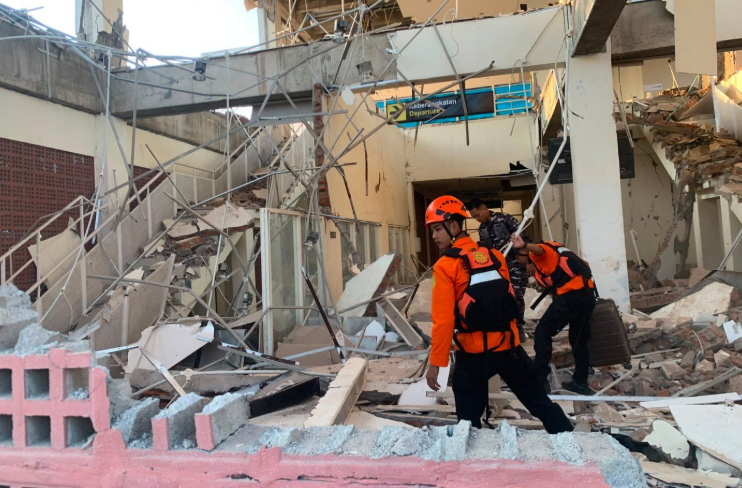
The earthquake and dozens of aftershocks severely damaged hundreds of buildings. Early assessments identified more than 150 damaged homes, along with educational institutions, healthcare facilities, places of worship, offices and other public infrastructure. The full extent of the destruction remains uncertain because the affected region is remote and mountainous. Landslides have blocked access to some villages, complicating rescue and assessment efforts.
Video from the port in Maumere showed concrete falling from a terminal building onto passengers waiting for a ferry. Some people were thrown into the sea when a gangway collapsed. Local officials said some victims were killed in their sleep by collapsing rubble, while residents described being jolted from their beds and fleeing into the hills after the sea appeared to recede.
A tsunami warning prompted about 2,000 people to evacuate, but it was lifted roughly three hours later after no significant rise in sea level was detected. Authorities continue to advise people to remain calm, avoid coastal areas and stay away from damaged structures. Aid is being delivered by Indonesia’s disaster management agency, with 10,500 packages already reaching base operations. A second magnitude 6.9 earthquake elsewhere in Indonesia highlighted the country’s vulnerability to earthquakes and volcanic activity because it lies along the meeting point of three major tectonic plates.
Entities: Indonesia, Flores, Manggarai province, East Manggarai province, Sikka • Tone: urgent • Sentiment: negative • Intent: inform
16-08-2026
A magnitude 7.7 earthquake struck off eastern Indonesia on Saturday, killing at least 47 people and injuring more than a dozen, according to Indonesia’s National Disaster Mitigation Agency (BNPB). Dozens of aftershocks followed, prompting approximately 2,000 people to evacuate to safer areas. A tsunami warning issued after the earthquake was lifted about three hours later.
The worst-affected areas include Maumere, the main town in Sikka Regency on Flores Island, and Nagekeo, the region closest to the epicentre. Rescue workers in Maumere reported finding 20 dead, six injured and two people trapped beneath rubble. Officials said other residents remained trapped in buildings across the affected region, while landslides blocked roads and disrupted communications, preventing rescue teams from reaching Nagekeo. One team was attempting to reach the area by ferry after road access was blocked.
Authorities reported damage to homes, warehouses, government facilities, schools, health facilities, places of worship and office buildings. Preliminary data listed 157 homes as heavily damaged, 41 as moderately damaged and 148 as lightly damaged. Power outages and traffic congestion were also reported. The provincial governor said at least five people died when buildings collapsed while they slept.
Residents described intense shaking that lasted about a minute and caused people to flee their homes. Some, including residents near Maumere’s port, moved to higher ground and remained away from their homes because of fears of further tremors. Strong shaking was reported across East Nusa Tenggara, West Nusa Tenggara and parts of South Sulawesi. Indonesia lies along the Pacific Ring of Fire, a seismically active zone where tectonic plates meet and earthquakes and volcanic activity are common. Rescue and damage assessments were continuing, particularly in areas isolated by landslides and communication disruptions.
Entities: Indonesia, 7.7-magnitude earthquake, National Disaster Mitigation Agency (BNPB), Basarnas, Maumere • Tone: urgent • Sentiment: negative • Intent: inform
16-08-2026
A magnitude 7.7 earthquake struck Indonesia’s Flores region in East Nusa Tenggara early Saturday, killing at least 47 people and injuring dozens, according to disaster management officials. The death toll was revised upward from an earlier estimate and was expected to rise because landslides had buried or isolated remote villages across several regencies. At least 50 people were hospitalized, 157 houses were flattened, nearly 200 others were damaged, and approximately 2,000 villagers were moved to temporary shelters. More than 100 public facilities, including schools, medical centers, and churches, were also destroyed or damaged.
The earthquake was followed by at least 235 aftershocks, including one measuring 6.2. A tsunami warning prompted coastal residents to move to higher ground, but authorities later lifted it after monitoring detected no significant sea-level changes. Power outages, communication disruptions, and landslides blocking the Trans-Flores highway complicated rescue and relief efforts. Hospitals evacuated patients and moved equipment outdoors, while Indonesia’s National Disaster Management Agency deployed a helicopter to support logistics and possible evacuations in the remote island region.
A second magnitude 6.4 earthquake struck western Sumatra later the same day, according to the U.S. Geological Survey. Indonesia is especially vulnerable to earthquakes and volcanic activity because it lies along the Pacific “Ring of Fire.” The article places the disaster in the context of earlier deadly events, including the 1992 Flores earthquake and tsunami, the 2018 Sulawesi disaster, and the 2004 Indian Ocean tsunami.
Entities: 7.7-magnitude Flores earthquake, 6.4-magnitude Sumatra earthquake, Flores Island, East Nusa Tenggara, Ende • Tone: urgent • Sentiment: negative • Intent: inform
16-08-2026
A powerful 7.7-magnitude earthquake struck north of Flores Island in Indonesia’s eastern region early Saturday, killing at least 40 people and injuring 50 others, according to rescue official Fathur Rahman. The shallow earthquake, which occurred at a depth of roughly 10 kilometres, caused panic in several areas as residents fled into the streets amid reports of crumbling buildings.
Authorities issued a tsunami warning after the quake, but Indonesia’s Meteorology, Climatology, and Geophysical Agency (BMKG) later lifted it after detecting no significant sea-level rises threatening coastal communities. BMKG deputy director Nelly Florida Riama warned that aftershocks were continuing and urged the public to remain calm, avoid rumours, and follow official information.
The National Agency for Disaster Countermeasure (BNPB) said approximately 2,000 people in Nagekeo Regency evacuated themselves. Tremors were reported across multiple regencies in East Nusa Tenggara, West Nusa Tenggara, and South Sulawesi. Authorities continued assessing the damage and emergency needs.
A second earthquake, measuring 6.9 in magnitude, later struck near Pematangsiantar on the western island of Sumatra at a depth of about 183 kilometres. Because deeper earthquakes generally produce less intense surface shaking, officials said it was expected to cause less destruction than the shallow Flores-area quake, although its effects were still being evaluated.
European Commission President Ursula von der Leyen offered condolences to victims’ families and said the European Union was prepared to deploy Copernicus Earth-observation satellites to support search-and-rescue operations. The article highlights the continuing aftershock risk, the lifting of the tsunami warning, widespread evacuations, and the ongoing response to the disaster.
Entities: 7.7-magnitude earthquake, Indonesia, Flores Island, East Nusa Tenggara, Nagekeo Regency • Tone: urgent • Sentiment: negative • Intent: inform
16-08-2026
A powerful 7.7-magnitude earthquake struck off Indonesia on Saturday, 15 August 2026, causing panic and significant damage in the Flores region. Dramatic footage recorded in Maumere shows people running for safety as the ground shook. The video also captures part of the terminal building at Lorens Say Port collapsing during the quake.
According to the article, the earthquake killed at least 20 people and damaged buildings and homes. Authorities reported that six people were injured, while two people remained missing after a landslide triggered by the earthquake. Several aftershocks followed the initial tremor, adding to the danger and uncertainty for residents and emergency responders.
A tsunami warning was issued for parts of eastern Indonesia as a precaution. The warning was later lifted after monitoring detected no significant changes in sea levels. The report focuses on the immediate effects of the earthquake, including the visible destruction, public panic, casualties, landslide-related dangers and ongoing aftershock risk. The accompanying footage from Maumere provides visual evidence of the severity of the event and the rapid response of people seeking safety.
Entities: Indonesia, Flores region, Maumere, Lorens Say Port, 7.7-magnitude earthquake • Tone: urgent • Sentiment: negative • Intent: inform
16-08-2026
A magnitude 7.7 earthquake struck off Indonesia’s Flores region early Saturday, August 15, 2026, causing buildings and homes to collapse, triggering panic and killing at least 38 people, according to the article’s headline and updated report. The U.S. Geological Survey said the shallow earthquake occurred at a depth of 10 kilometres, with its epicentre 68 kilometres north-northwest of Ende in East Nusa Tenggara province. Several aftershocks followed.
Authorities initially issued a tsunami warning for parts of East Nusa Tenggara, West Nusa Tenggara, South Sulawesi and Southeast Sulawesi. Coastal residents were urged to move to higher ground and stay away from beaches and riverbanks. The warning was later lifted after Indonesia’s Meteorology, Climatology and Geophysics Agency detected no significant sea-level changes threatening coastal communities.
The earthquake was felt across Flores island, where early reports indicated extensive damage. The Maumere Search and Rescue Agency initially reported two deaths and two injuries, while Indonesia’s disaster management agency reported severe structural damage. Hospitals evacuated patients as a precaution, moved medical equipment outdoors and established temporary treatment areas.
Residents reported damage in Sikka, including the collapse of a waiting room at Maumere’s port terminal. At St. Peter Major Seminary, students and nuns fled when an assembly hall roof collapsed. Seminary rector Rev. Guidelbertus Tanga said at least one priest broke his leg after jumping from a second-floor building.
The article places the disaster in the context of Indonesia’s location on the Pacific “Ring of Fire,” which makes the country vulnerable to earthquakes and volcanic activity. Flores experienced a deadly tsunami after a powerful earthquake in 1992, while a 2018 magnitude 7.5 earthquake generated a destructive localized tsunami. The supplied article ends mid-sentence while discussing the 2018 disaster.
Entities: Magnitude 7.7 Flores earthquake, Flores island and Flores region, East Nusa Tenggara province, Ende, Maumere • Tone: urgent • Sentiment: negative • Intent: inform
16-08-2026
A powerful magnitude-7.7 earthquake struck off eastern Indonesia early Saturday, August 15, 2026, killing at least 51 people, according to the National Disaster Mitigation Agency (BNPB). The worst-affected areas are in East Nusa Tenggara, including the port town of Maumere on Flores Island. Rescue workers in Maumere initially reported 20 deaths, six injuries and two people trapped beneath rubble.
The region of Nagekeo, closest to the earthquake’s epicentre, remained inaccessible to emergency personnel because communications were disrupted and landslides blocked roads. A rescue team was trying to reach the area by ferry. About 2,000 residents of Nagekeo were evacuated, while authorities reported damage to homes, warehouses and government facilities, along with traffic congestion and power outages.
The governor of East Nusa Tenggara said at least five people died when a building collapsed while they were sleeping. Preliminary assessments recorded 157 heavily damaged homes, 41 moderately damaged homes and 148 lightly damaged homes. Eighty-seven schools, 18 health facilities, five places of worship and six office buildings were also damaged.
The earthquake was felt across East Nusa Tenggara, West Nusa Tenggara and parts of South Sulawesi, with residents reporting shaking lasting roughly one minute. Tsunami waves of less than one metre were recorded in several locations, but the warning was lifted about three hours after the quake. Indonesia’s geophysics agency, BMKG, said the first tremor occurred at 4:58 a.m. at a depth of 15 kilometres and was followed by aftershocks.
The agency noted that the same area suffered extensive destruction in a magnitude-7.5 earthquake in 1992. Indonesia lies along the seismically active Pacific Ring of Fire. The United Arab Emirates expressed condolences and solidarity with Indonesia and wished injured people a speedy recovery.
Entities: Magnitude-7.7 earthquake, East Nusa Tenggara, Flores Island, Maumere, Sikka Regency • Tone: urgent • Sentiment: negative • Intent: inform
16-08-2026
Indonesia experienced a concentrated series of powerful earthquakes within a 24-hour period, including a shallow 7.7-magnitude earthquake off Flores in East Nusa Tenggara. The quake struck near Ende at about 5:58 a.m. local time and caused widespread shaking, building damage, landslides and at least 47 deaths. Maumere in Sikka Regency was reportedly among the worst-affected locations, with fatalities linked to collapsing buildings. Rescue and relief efforts were hindered by blocked roads, damaged infrastructure and disrupted communications.
The Flores earthquake prompted tsunami warnings for parts of eastern Indonesia. Although the warning was later lifted, tsunami waves were recorded, including one measuring approximately 1.6 metres in Riung village. The main earthquake was followed by more than 230 aftershocks, including a tremor of about magnitude 6.1, increasing risks for damaged buildings and emergency responders.
The article also reports that a separate 6.9-magnitude earthquake struck Sumatra. Because it occurred at a depth of about 172 kilometres, it was described as less destructive than the Flores event. Data from EarthquakeTrack reportedly listed additional significant tremors, including earthquakes measuring 6.1 and 5.7, as well as 35 earthquakes above magnitude 1.5 during the preceding 24 hours.
Indonesia is particularly vulnerable to seismic disasters because it lies along the Pacific Ring of Fire, where several tectonic plates meet. The combination of frequent earthquakes, shallow offshore fault activity and the potential for tsunamis creates significant risks for communities across the archipelago.
Entities: Indonesia, Flores, East Nusa Tenggara, Ende, Maumere • Tone: urgent • Sentiment: negative • Intent: inform