25-09-2026
Hawaii’s Big Island was preparing for Hurricane Nolo, which forecasters expected to pass just south of the islands through the weekend and potentially strengthen into a major hurricane on Saturday. With maximum sustained winds reaching 165 kilometres an hour, Nolo was forecast to bring dangerous surf, flash flooding and as much as 38 centimetres of rain in parts of the Big Island, with isolated totals possibly reaching 64 centimetres. Maui and other islands also faced the risk of heavy rain, flooding and mudslides. Officials urged people to shelter in safe locations and avoid travel through floodwaters and high winds. Hawaii activated more than 230 National Guard members, closed some schools, prepared shelters and sandbag distribution sites, and received federal emergency support. Residents and visitors prepared for flooding and flight disruptions, while utility crews returned to the islands ahead of possible outages. The storm threatened areas still saturated from recent rain and affected by Hurricane Lala in August.
The article also reports that Hurricane Polo was moving toward Mexico’s Baja California peninsula after bringing damaging conditions to the Pacific coast. Authorities closed ports, opened shelters, evacuated some coastal residents and deployed 15,000 security personnel. In Lázaro Cárdenas, waves and seawater damaged homes and businesses; one restaurant owner described severe damage and the loss of her livelihood. Polo’s moisture could also contribute to flash flooding in parts of Arizona and New Mexico. The report places these storms in a wider Pacific and Atlantic pattern associated with El Niño, which can increase Pacific cyclone activity while tending to suppress Atlantic hurricane activity. Other active storms mentioned include Hurricane Odalys and Tropical Storms Fay and Gonzalo.
Entities: Hurricane Nolo, Hurricane Polo, Hawaii’s Big Island, Maui, Baja California peninsula • Tone: urgent • Sentiment: negative • Intent: inform
25-09-2026
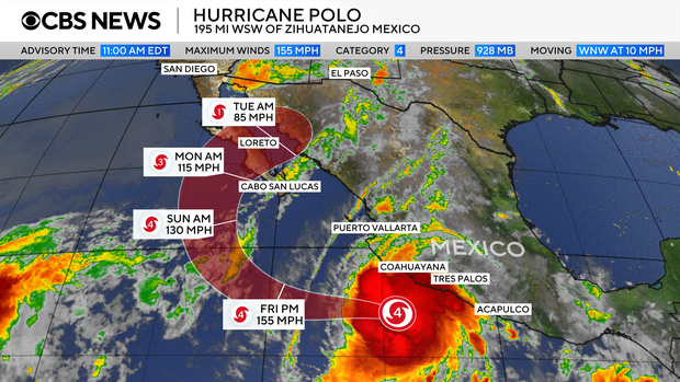
Hurricane Polo fluctuated between Category 4 and Category 5 strength on Thursday as it moved northwest, beginning to pull away from Mexico’s southwestern coast. The National Hurricane Center expected the storm to remain offshore, although its outer rainbands were forecast to affect the region. Polo’s center was about 195 miles from Manzanillo, Colima, and the storm was moving at 10 mph. Its hurricane-force winds extended up to 40 miles from the center, with tropical-storm-force winds reaching roughly 125 miles.
Forecasters expected some additional strengthening early Friday, followed by weakening Friday night and Saturday. Despite the storm’s offshore track, heavy rain could bring life-threatening flooding and mudslides, particularly in steep terrain. Parts of Michoacán, Colima, Jalisco and Nayarit could receive another 2 to 4 inches of rain, with up to 6 inches in some areas; coastal parts of Jalisco and Guerrero could see another 1 to 2 inches. Dangerous surf and rip currents were also expected to affect the southwestern coast and parts of Baja California. The Mexican government canceled tropical-storm watches and warnings late Thursday, but officials continued preparations: evacuations were ordered, shelters opened and military troops deployed. Schools were suspended in Acapulco and in coastal municipalities of Michoacán.
Polo had rapidly intensified between Monday and Tuesday, with winds rising from 45 mph to 150 mph in about a day. Its peak sustained winds reached 180 mph, above the Category 5 threshold of 157 mph. The hurricane center called the intensification “truly remarkable.” Polo’s central pressure made it the Eastern Pacific’s second-strongest hurricane on record, behind Hurricane Patricia in 2015; its wind speed tied Hurricane Rick’s 2009 record as the region’s third-highest. The article attributes elevated Pacific cyclone activity to unusually strong El Niño conditions, which bring warmer water and moist air and reduce wind shear. Separately, Hurricane Nolo strengthened in the Pacific as it approached Hawaii’s Big Island.
Entities: Hurricane Polo, Hurricane Nolo, U.S. National Hurricane Center, Mexico, Manzanillo • Tone: urgent • Sentiment: negative • Intent: inform
25-09-2026
Two major Pacific hurricanes threatened communities in Hawaii and Mexico on Thursday, while other tropical systems formed or remained offshore. Hurricane Nolo strengthened and turned toward Hawaii’s Big Island, where forecasters warned of 15 to 30 inches of rain, with locally higher totals through Saturday. Maui also faced a risk of life-threatening flooding. The Big Island’s southeastern region was especially vulnerable because it had already been hit by Hurricane Lala in August and remained saturated; some communities had been isolated and roads washed out. Hawaii closed schools, urged residents to prepare emergency kits, issued an emergency proclamation, and activated more than 230 National Guard members. Utility crews were repositioned to prepare for the storm.
Hurricane Polo, which fluctuated between Category 4 and 5, threatened Mexico’s Pacific coast with torrential rain, flooding, and landslides. It was expected to regain Category 5 strength before gradually weakening, moving offshore and then turning back toward land. In Lázaro Cárdenas, waves and seawater had already damaged homes and businesses, leaving debris and mud in the streets. Authorities opened shelters, evacuated people from high-risk areas, suspended schools, and deployed 15,000 security personnel. Restaurant owner Alicia Contreras described severe damage from 15-foot waves and said her family had no other source of income. Residents’ fears were heightened by Hurricane Otis, which devastated Acapulco in 2023.
The article links the unusually active Pacific season to El Niño, which tends to increase Pacific tropical cyclone activity even as it dampens Atlantic hurricane activity. Hawaii had also experienced major flooding, an earthquake, and other hurricanes that year. Elsewhere, Hurricane Odalys remained far from land, Tropical Storm Fay re-formed in the Atlantic, and Tropical Storm Gonzalo formed near the Cape Verde Islands and was forecast to pass near or over some of them.
Entities: Hurricane Nolo, Hurricane Polo, Hawaii’s Big Island, Maui, Mexico’s Pacific coast • Tone: urgent • Sentiment: negative • Intent: inform
25-09-2026
The article reports on three major weather events. Hurricane Polo is moving towards Mexico’s Baja California region during an unusually active Pacific hurricane season. On 22 September, the storm registered a central pressure of 892 millibars, making it the second-most intense hurricane on record in the east Pacific. Exceptionally warm Pacific waters are helping it maintain its strength. Polo has maximum sustained winds of about 150mph, with hurricane-force winds extending roughly 40 miles from its centre and tropical-storm-force winds reaching up to 125 miles. The storm is forecast to turn west-north-west and then north-west. Despite possible fluctuations in intensity, it is expected to remain powerful, bringing risks from strong winds, torrential rain and dangerous seas.
The article also describes a 988-millibar low-pressure system, classified as a tropical storm, along India’s east coast. Odisha and nearby areas are experiencing heavy rain, with some locations potentially receiving more than 200mm in 24 hours and the heaviest hourly rainfall exceeding 30mm. The downpours could cause surface water and localized flooding, especially in low-lying areas or places with poor drainage. Coastal Odisha is also facing gusty winds forecast to reach 50–60mph, which could disrupt travel, infrastructure and power supplies. Numerous schools have closed as a safety measure.
Finally, the report notes that summer heat is persisting into meteorological autumn in Iberia. Temperatures reached the high 30s Celsius on 23 September, and Alvega, Portugal, recorded 41.7C—a temperature that surpassed many July records from previous decades.
Entities: Hurricane Polo, Ed Walton, MetDesk, Baja California, Mexico • Tone: analytical • Sentiment: neutral • Intent: inform