15-08-2026
A powerful 7.7-magnitude earthquake struck off eastern Indonesia on August 15, 2026, causing damage to buildings and prompting residents to flee toward higher ground. Authorities issued a tsunami warning following the offshore earthquake, indicating concern that the seismic activity could generate dangerous waves along nearby coastlines. Several aftershocks were also recorded, adding to the risk and uncertainty for affected communities.
The brief report does not identify the precise location of the epicenter, the number of damaged buildings, whether anyone was injured or killed, or the extent of any tsunami impact. It also does not provide details about the warning’s duration or whether evacuations were formally ordered. However, residents’ movement to higher ground suggests that people responded quickly to the potential coastal danger.
The earthquake and subsequent aftershocks created an urgent situation for emergency authorities and residents in eastern Indonesia. Officials would likely have been monitoring seismic activity and coastal conditions while assessing damage and communicating safety information. The report’s central focus is the immediate threat posed by the major earthquake, the tsunami warning, and continuing aftershocks rather than the longer-term recovery process.
Entities: Eastern Indonesia, Indonesia, 7.7-magnitude earthquake, Tsunami warning, Aftershocks • Tone: urgent • Sentiment: negative • Intent: inform
15-08-2026
A magnitude 7.7 earthquake struck off Indonesia’s Flores Island early on August 15, killing at least 20 people and causing widespread damage in East Nusa Tenggara province. The United States Geological Survey said the earthquake occurred at 5:58am local time, with its epicentre approximately 68 kilometres north-northwest of Ende and at a depth of 10 kilometres. Three aftershocks measuring 5.9, 5.6 and 6.1 followed within 30 minutes.
Rescuers working around the port town of Maumere reported finding 20 bodies, six injured people and two individuals trapped under rubble. However, emergency teams had not yet reached Nagekeo regency, the area closest to the epicentre, where communications had been disrupted. Officials warned that the death toll could rise as search-and-rescue operations continued. Collapsed buildings, damaged homes, warehouses and government facilities were reported, while power and communications outages hampered the delivery of information and emergency assistance.
Indonesia’s disaster mitigation agency said about 2,000 residents in Nagekeo had evacuated. The country’s meteorological agency issued a tsunami warning for affected coastlines, advising people to move away from beaches and riverbanks and seek higher ground. The warning was later lifted.
Authorities continued to assess the extent of the damage and monitor the threat from additional aftershocks. Al Jazeera correspondent Jessica Washington reported that aftershocks could continue for several days and that some northern areas of Flores had been ordered to evacuate. USGS estimates indicated that more than half a million people may have experienced very strong shaking, with millions more feeling moderate to strong tremors across the region.
Indonesia lies on the Pacific Ring of Fire and is highly vulnerable to earthquakes. Flores experienced a similarly powerful earthquake and tsunami in December 1992, which killed more than 2,500 people.
Entities: Magnitude 7.7 Flores earthquake, Flores Island, Indonesia, East Nusa Tenggara province, Ende • Tone: urgent • Sentiment: negative • Intent: inform
15-08-2026
A powerful magnitude 7.7 earthquake struck off eastern Indonesia early Saturday, causing deaths, infrastructure disruption and continuing seismic activity across the region. At least five people were killed, while dozens of aftershocks followed the initial quake, increasing risks for residents and emergency responders. The earthquake also triggered landslides and blocked roads, complicating access to affected communities and potentially slowing rescue, relief and damage-assessment efforts. Al Jazeera reporter Jessica Washington provides an on-the-ground account of the situation, reporting from the affected area as the region continues to experience aftershocks. The report emphasizes the immediate human toll and the physical disruption caused by the earthquake, particularly the landslides and road blockages. However, the brief account does not provide further details about the precise location of the epicentre, the number of people injured or displaced, the extent of structural damage, or the emergency response. It also does not identify which authorities or agencies are coordinating relief operations. Published on 15 August 2026, the report presents the earthquake as an unfolding disaster requiring continued monitoring because of the ongoing aftershocks and the possibility of additional landslides or damage. Its primary focus is to update audiences on the confirmed deaths and immediate conditions on the ground in eastern Indonesia.
Entities: Eastern Indonesia, Indonesia, 7.7 magnitude earthquake, Jessica Washington, Al Jazeera • Tone: urgent • Sentiment: negative • Intent: inform
15-08-2026
A 7.7-magnitude earthquake struck off Indonesia’s island of Flores shortly before 05:00 local time on Saturday, causing deaths, injuries and damage across the remote, mountainous East Nusa Tenggara region. The article’s body reports at least 14 deaths, although the supplied title says five dead. Indonesia’s disaster mitigation agency said the casualty figures were preliminary as search-and-rescue teams continued working and assessing damaged buildings.
The earthquake occurred at a depth of 15km, making it relatively shallow and potentially more destructive at the surface. Strong aftershocks followed, including one measuring 6.1. A tsunami warning prompted residents to move inland, but it was lifted approximately three hours after the initial earthquake. About 2,000 people evacuated or relocated independently, including residents of Nagekeo, while authorities urged people to stay away from coastal areas and buildings with cracks or structural damage.
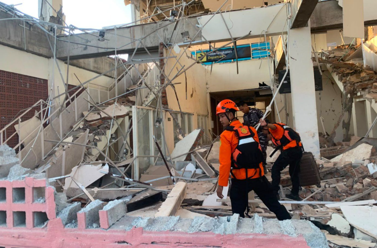
Video from the Lorens Say Port in Maumere showed concrete falling from a terminal onto passengers waiting for an inter-island ferry. Several people were thrown into the sea when a gangway collapsed. East Nusa Tenggara Governor Emanuel Melkiades Laka Lena said some victims were killed in their sleep by collapsing rubble.
Residents described intense shaking, panic and continued fear of returning indoors because of the aftershocks. Arnold Welianto, from a coastal village in Sikka, said residents fled toward higher ground after the sea receded and remained outdoors. The article notes that Indonesia is highly vulnerable to earthquakes and volcanic activity because it lies at the meeting point of three major tectonic plates.
Entities: 7.7-magnitude earthquake, Flores, Indonesia, East Nusa Tenggara, Maumere, Lorens Say Port • Tone: urgent • Sentiment: negative • Intent: inform
15-08-2026
A powerful magnitude 7.7 earthquake struck Indonesia’s Flores region early Saturday, killing at least 20 people according to the article’s headline and opening report, damaging or collapsing buildings, and triggering widespread panic. The U.S. Geological Survey said the earthquake occurred at 5:58 a.m. local time, with its epicenter 42 miles north-northwest of Ende in East Nusa Tenggara province. Several aftershocks followed.
Authorities issued a tsunami warning and urged residents in coastal areas to move to higher ground. The warning was later lifted after Indonesia’s Meteorology, Climatology and Geophysics Agency reported no significant sea-level changes threatening coastal communities. The article notes that preliminary police reports identified two deaths in Sikka Regency and three in Manggarai Regency, while power outages and communication disruptions hindered the collection of casualty and damage information and complicated search-and-rescue operations.
Buildings and homes were severely damaged in multiple locations. Local television footage showed hospitals evacuating patients and moving beds, oxygen cylinders, IV stands, and other equipment outdoors while staff established temporary treatment areas. Residents reported extensive structural damage, including the collapse of a waiting room at the port terminal in Maumere.
At St. Peter Major Seminary in Sikka, students and nuns fled during morning Mass after the roof of an assembly hall began collapsing. The seminary rector, the Rev. Guidelbertus Tanga, said at least one priest broke his leg after jumping from a second-floor building. Panic and damage were also reported in Bima, in neighboring West Nusa Tenggara province, and in parts of southern Sulawesi. The article portrays an unfolding disaster response in a region vulnerable to deadly earthquakes, with authorities continuing to assess casualties and damage.
Entities: 7.7-magnitude earthquake, Flores region, East Nusa Tenggara province, Ende, Sikka Regency • Tone: urgent • Sentiment: negative • Intent: inform
15-08-2026
A magnitude 7.7 earthquake struck off the coast of Indonesia’s Flores Island early Saturday, killing at least five people and causing severe damage across parts of East Nusa Tenggara province. Authorities reported two deaths in Sikka Regency and three in Manggarai Regency. The US Geological Survey said the epicenter was only 10 kilometers below the seabed, making the earthquake especially destructive. Indonesia’s Meteorology, Climatology, and Geophysics Agency recorded the initial tremor at 4:58 a.m. local time at a depth of 15 kilometers, followed by dozens of aftershocks, including one measuring magnitude 6.1.
The earthquake damaged or collapsed buildings, disrupted electricity, and hindered rescue operations because of communication problems. Video from Maumere, the main town of Sikka Regency, showed part of a building collapsing as residents fled into the streets. A resident said the waiting room at the Pelni port terminal had collapsed. Hospitals and health centers evacuated patients and staff as a precaution, while a seminary on Flores Island reported panic and injuries.
Authorities issued a tsunami warning for parts of East and Southeast Nusa Tenggara, South Sulawesi, and Southeast Sulawesi. Residents were told to move away from beaches and riverbanks and, in some areas, to seek higher ground. Waves of less than one meter were recorded before the warning was lifted approximately three hours after the earthquake. Officials said they would continue monitoring sea levels.
The article places the disaster in the context of Indonesia’s location on the seismically active Pacific Ring of Fire. It recalls major earthquakes and tsunamis in Flores in 1992, the Indian Ocean in 2004, Lombok and Sumbawa in 2018, and Palu in 2018.
Entities: Flores Island, Indonesia, Sikka Regency, Manggarai Regency, East Nusa Tenggara province • Tone: urgent • Sentiment: negative • Intent: inform
15-08-2026
A magnitude 7.7 earthquake struck off Flores island in eastern Indonesia early Saturday, August 15, 2026, causing buildings and homes to collapse, killing at least five people according to the headline and prompting widespread evacuations. The U.S. Geological Survey said the shallow earthquake occurred at 5:58 a.m. local time at a depth of 10 kilometres, about 68 kilometres north-northwest of Ende in East Nusa Tenggara province. Several aftershocks followed.
Indonesian authorities initially issued a tsunami warning for coastal areas in East Nusa Tenggara, West Nusa Tenggara, South Sulawesi and Southeast Sulawesi. Residents were told to move to higher ground and stay away from beaches and riverbanks. The warning was later lifted after Indonesia’s Meteorology, Climatology and Geophysics Agency reported no significant sea-level changes threatening coastal communities.
Preliminary reports from the Maumere Search and Rescue Agency cited by Indonesia’s disaster management agency said at least two people had died and two others were injured, while later reporting and the article headline placed the death toll at five. Hospitals evacuated patients and moved medical equipment outdoors, establishing temporary treatment areas. Reports from across Flores described extensive structural damage and panic among residents.
Residents in Sikka reported damaged buildings and the collapse of a waiting room at Maumere’s port terminal. At St. Peter Major Seminary, students and nuns fled when an assembly-hall roof collapsed; a priest reportedly broke his leg after jumping from a second-floor building. The article places the disaster in the broader context of Indonesia’s vulnerability to earthquakes and tsunamis because it lies along the Pacific “Ring of Fire.” It recalls deadly events in Flores in 1992, Palu in 2018 and the Mentawai Islands in 2010.
Entities: 7.7-magnitude Flores earthquake, Flores island, Indonesia, East Nusa Tenggara province, Ende • Tone: urgent • Sentiment: negative • Intent: inform
15-08-2026
A magnitude 7.7 earthquake struck the coast of eastern Indonesia early Friday, prompting Indonesian authorities to issue a tsunami warning. According to the US Geological Survey, the earthquake occurred at approximately 4:58 a.m. local time in the Flores region at a depth of 21.75 miles, with Reuters cited for additional details. At least three aftershocks followed, according to the European-Mediterranean Seismological Centre, increasing concern that a tsunami could reach nearby coastlines.
The article says there was no publicly available information about the full extent of the damage. However, videos reportedly recorded by local residents showed buildings swaying and collapsing while crowds ran toward open areas to escape falling debris. Other footage appeared to show the shoreline rapidly receding and exposing the seafloor. The article interprets this as potentially indicating that the trough, or lowest point, of a tsunami wave had reached the coast and that a much larger wall of water could follow.
The earthquake occurred in Indonesia, an archipelagic country located on the Pacific Ring of Fire, a region known for intense tectonic activity and frequent earthquakes and volcanic eruptions. The report presents such seismic volatility as a recurring danger for the country. It also briefly compares the event with a magnitude 7.4 earthquake that struck Colombia on Monday, described as the strongest there in more than a decade.
The article focuses on the immediate tsunami threat, scenes of public panic, and the uncertainty surrounding casualties and structural damage. It does not provide confirmed figures for deaths, injuries, evacuations, or the eventual arrival of a tsunami.
Entities: 7.7-magnitude earthquake, Indonesia, Flores region, Indonesian coastline, Tsunami warning • Tone: urgent • Sentiment: negative • Intent: inform
15-08-2026
At least 20 people were killed after a magnitude-7.7 earthquake struck off eastern Indonesia early Saturday, August 15, 2026. Rescue workers in and around Maumere, the main town of Sikka Regency on Flores Island, recovered 20 bodies and found six injured people, while two others remained trapped under rubble, according to Fathur Rahman, head of the city’s rescue agency.
The area closest to the epicentre, Nagekeo, had not yet been reached by emergency personnel because communications were disrupted and roads were blocked by landslides. Rescue teams were attempting to reach the region by ferry. Approximately 2,000 residents were evacuated, and officials reported damage to houses, warehouses and government buildings, as well as traffic congestion and power outages.
Emanuel Melkiades Laka Lena, governor of East Nusa Tenggara, said at least five people died when a building collapsed on them while they slept. A resident of Talibura described the earthquake as extremely powerful and said 13 people inside her home fled to safety.
Shaking was felt across East Nusa Tenggara, West Nusa Tenggara and parts of South Sulawesi, with residents reporting that the tremors lasted about one minute. Tsunami waves measuring less than one metre were recorded in several locations, but the tsunami warning was lifted roughly three hours after the earthquake.
Indonesia’s geophysics agency, BMKG, recorded the initial quake at 4:58 a.m. local time at a depth of 15 kilometres, followed by several aftershocks. Officials noted that the same area experienced a magnitude-7.5 earthquake in 1992 that caused extensive destruction. The article places the disaster in the broader context of Indonesia’s location along the Pacific Ring of Fire, a highly active seismic zone associated with earthquakes and volcanic eruptions.
Entities: Magnitude-7.7 earthquake, East Nusa Tenggara, Maumere, Sikka Regency, Flores Island • Tone: urgent • Sentiment: negative • Intent: inform