29-09-2026
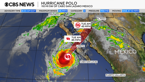
Hurricane Polo made landfall on Mexico’s northern Pacific coast, striking Baja California Sur with maximum sustained winds of 110 mph (175 km/h) and heavy rain. It came ashore just south of Las Barrancas and was moving northeast. Forecasters expected the storm’s core to cross Baja California Sur before moving inland over southern Sonora later on Tuesday. Residents in threatened areas were urged to seek shelter; some, including shopkeeper María Palomino, spent the night in temporary shelters. A local fishing and whale-watching guide described the storm as coming “with full force.”
The National Hurricane Center forecast that Polo would weaken over the peninsula but remain at hurricane strength when it made a second landfall on mainland Mexico. Meteorologists warned that 6 to 12 inches (150–300mm) of rain could cause life-threatening flooding and mudslides, particularly in steep terrain. Storm surge and destructive waves threatened coastal areas. Power cuts had already been reported, and flooding and overtopping waves were reported around Puerto San Carlos. Dangerous surf and rip currents were expected to continue along parts of Mexico’s north-western coast and Baja California.
The article also describes the storm’s wider effects. Polo was fueled by unusually warm waters associated with El Niño, which has contributed to a more active Pacific hurricane season. As the system moves northeast, tropical moisture is expected to bring excessive rainfall and flash-flood risks to parts of the US. Rain was already falling in Arizona and California, while Polo’s remnants and Hurricane Odalys were expected to add to rainfall moving across the southern plains. Some locations could receive 6 or 7 inches by Thursday, with Arizona, New Mexico, Colorado and Utah among the states affected.
Entities: Hurricane Polo, Baja California Sur, Las Barrancas, Sonora, María Palomino • Tone: urgent • Sentiment: negative • Intent: inform
29-09-2026
Hurricane Polo made landfall in Baja California Sur, Mexico, with maximum sustained winds of 110 mph, making it a strong Category 2 hurricane. Its winds later fell to 80 mph, a Category 1 strength. The National Hurricane Center said the storm would continue across the peninsula before moving inland over southern Sonora, where it was expected to make a second landfall while still a hurricane. It would then weaken as it moved farther inland.
The storm poses a significant flooding threat beyond Mexico. Flood watches were in effect across 11 U.S. states, including much of Arizona and New Mexico and portions of several other states. More than 14 million people faced the risk of major flooding. The National Weather Service’s Weather Prediction Center warned that moisture from Polo could trigger flash flooding from the Four Corners eastward into the Central Plains and urged people not to drive through floodwaters.
Authorities issued hurricane and tropical storm warnings and watches for parts of Baja California Sur and mainland Mexico. The hurricane center forecast 6 inches to a foot of rain for Baja California Sur and 4 to 6 inches, with up to 8 inches possible, for Sonora. Mexican officials ordered evacuations, opened shelters and deployed troops. Acapulco suspended school classes, while shelters remained open in Guerrero.
Polo had rapidly intensified between September 21 and 22, with winds increasing from 45 mph to 150 mph in about a day; its peak winds reached 180 mph, exceeding the Category 5 threshold. The hurricane center called the transformation “truly remarkable.” Polo’s central pressure made it the Eastern Pacific’s second-strongest hurricane on record, behind Hurricane Patricia, while its wind speed tied Hurricane Rick as the region’s third-strongest. The article attributes unusually active Pacific cyclone conditions to a strong El Niño, and also notes that Hurricane Nolo brought heavy rain and winds near Hawaii’s Big Island.
Entities: Hurricane Polo, Baja California Sur, Sonora, Southwest United States, Four Corners Region • Tone: urgent • Sentiment: negative • Intent: warn
29-09-2026
Hurricane Polo made landfall on Tuesday near Las Barrancas on Mexico’s Baja California peninsula as a Category 3 storm, bringing winds of up to 175 kilometres per hour, flooding and power outages. The US National Hurricane Centre warned of life-threatening winds and flash flooding. In Puerto San Carlos, waves and storm surges breached sections of a sand barrier and sent water into streets. The town lost power, while palm trees were battered by strong winds and authorities told residents to shelter.
Residents took precautions, including whale-watching and fishing guide Juan Manuel Sarabia, who boarded up and reinforced his home. However, few homes or businesses in the town appeared to be protected against flooding. A police officer told AFP he thought the entire town should have been evacuated. Shopkeeper Maria Palomino, sheltering at a nearby high school, said she would rather face the storm among people she knew. Authorities opened 169 shelters across Baja California Sur.
Mexico’s meteorological service warned that storm surges and heavy rain could cause “very severe” damage. The military deployed nearly 7,000 troops in the state; classes were suspended, some public servants were told to work from home, and maritime activities were halted. Meteorologists also issued heavy-rain and flood warnings for parts of 10 US states, including some experiencing drought.
The report links the unusually active Pacific hurricane season to a strong El Niño, which warms the central and eastern Pacific and affects winds and rainfall worldwide. Forecasters were also monitoring Tropical Storm Rachel off Mexico, which was expected to track parallel to the coast and could strengthen into a hurricane mid-week.
Entities: Hurricane Polo, Baja California Sur, Las Barrancas, Puerto San Carlos, US National Hurricane Centre (NHC) • Tone: urgent • Sentiment: negative • Intent: inform