17-08-2025

Tropical Cyclones Threaten Atlantic and Asia Regions

Date: 17-08-2025
Sources: bbc.com: 1 | nypost.com: 1 | scmp.com: 1
Image for cluster 1
Image Source:

Source: nypost.com

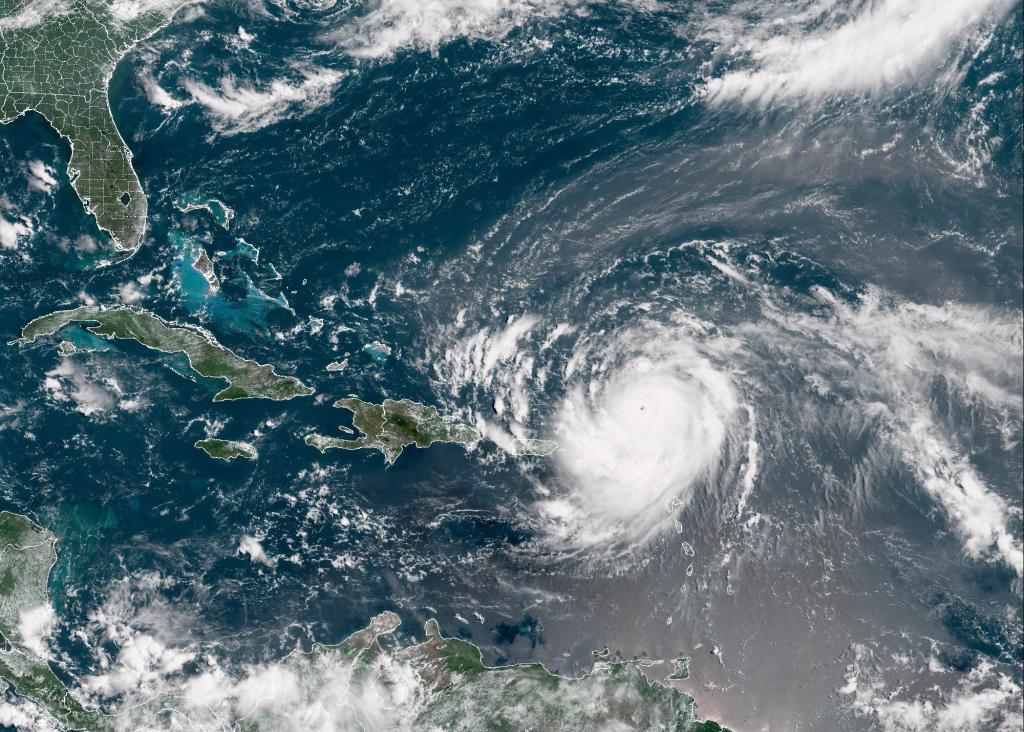
Image content: The image depicts a satellite view of a hurricane in the Atlantic Ocean, with the storm's white clouds spiraling around its center. The hurricane is positioned near the Bahamas and appears to be heading towards Florida. The surrounding ocean and landmasses are visible, with the southeastern United States, including Florida, and the Caribbean islands visible in the image.

Summary

Multiple tropical cyclones are intensifying across the Atlantic and Asia, posing threats to various regions including the Caribbean, US east coast, and Hong Kong. Hurricane Erin has rapidly intensified into a category 4 cyclone, while a tropical depression is affecting Hong Kong and Macau.

Key Points

  • Hurricane Erin intensifies to category 4 cyclone in the Atlantic
  • Heavy rain and flash flooding expected in the Caribbean and US east coast
  • Tropical depression affects Hong Kong and Macau with strong winds and thunderstorms

Articles in this Cluster

Hurricane Erin rapidly intensifies to category five storm

Hurricane Erin has rapidly intensified into a category five storm in the Atlantic Ocean, with maximum sustained winds of 160mph expected to strengthen further. The storm is forecast to pass north of the Leeward Islands, the Virgin Islands, and Puerto Rico, bringing heavy rain and potential flash flooding. Although it is not currently expected to make landfall in the mainland US, it will generate life-threatening surf waves and rip currents along the US east coast, particularly in Florida and the mid-Atlantic states. The US National Hurricane Center has warned of the storm's severity, and the US Coast Guard has imposed restrictions on vessels in affected ports.
Entities: Hurricane Erin, Mike Brennan, US National Hurricane Center, Caribbean, Leeward IslandsTone: neutralSentiment: negativeIntent: inform

Hurricane Erin remains an extremely dangerous Category 4 cyclone north of Caribbean

Hurricane Erin, the first major hurricane of the 2025 Atlantic hurricane season, has rapidly intensified into a Category 4 cyclone north of the Caribbean islands. Initially reaching Category 5 with winds of 160 mph, it has since weakened slightly. The hurricane is expected to pass north and east of the Caribbean over the next 48 hours, with rain totals of 2-4 inches expected, and isolated areas possibly receiving up to six inches. A Tropical Storm Watch has been issued for the Turks and Caicos and the southeast Bahamas. The National Hurricane Center is monitoring another region in the Atlantic for potential development.
Entities: Hurricane Erin, Caribbean, National Hurricane Center, Turks and Caicos, BahamasTone: neutralSentiment: negativeIntent: inform

No 1 typhoon signal in Hong Kong to remain in force until 8pm on Sunday | South China Morning Post

The No 1 typhoon signal will remain in force in Hong Kong until at least 8pm on Sunday due to a tropical depression. The Hong Kong Observatory reported that the depression would be at least 600km away from the city on Sunday morning. The weather is expected to be affected by the combined effect of the tropical depression and a high-pressure ridge over southeastern China, resulting in strong winds and squally showers with thunderstorms. Macau's Meteorological and Geophysical Bureau issued a No 3 typhoon signal, which will remain in effect throughout the day.
Entities: Hong Kong, Macau, Hong Kong Observatory, Pearl River Delta, GuangdongTone: neutralSentiment: neutralIntent: inform